April 18, 2024
(press release)
–
We are excited to announce that we have leveraged our partnership with Planet to enhance our customers' platform experience. As part of this collaboration, platform users can now view accurate, up-to-date, and seamless imagery captured by the world's largest fleet of over 200 Earth observation satellites. Planet’s satellite constellation images the entire world every day. These daily scenes are combined into quarterly mosaics to minimise cloud cover. From now on, satellite imagery displayed on the BeZero Carbon Markets platform will automatically update every quarter, to display the latest clear view from space. Our clients can compare this view side-by-side with previous quarters, all the way back to 2016. This enhancement provides platform users with a direct view of how things are changing on the ground, in and around carbon projects. Meanwhile, behind the scenes, our scientists are constantly monitoring all rated projects using near-real time data feeds from Planet, NASA, ESA, and other sources. Our enhanced geospatial features allows customers to compare and contrast Planet’s high-resolution satellite imagery using our time slider, showing how things have changed over the project’s lifetime, be this deforestation, tree planting, fire impacts, or seasonal changes in agricultural practices. Example use case for an Avoided Deforestation project in the Brazilian Amazon (Q1'2017 - Q1'2024). You are able to see how well the project is doing to protect the rainforest, compared to patterns of deforestation in the wider landscape. This is a useful visual complement to our dynamic baselines charts and maps, which rigorously quantify project effectiveness compared to statistically matched control areas. BeZero is setting new standards for seamless integration of remote sensing technologies for carbon risk assessment. Our partnership with Planet provides our scientists and customers access to their market-leading satellite data, as well as forest analytics including tree height, canopy cover and biomass. Planet’s data complement and enhance our methodologies and analysis, and support our work in providing world-leading ratings to help customers make informed decisions about their carbon investments and impact claims. Clicking on the Geospatial tab for any nature-based project will automatically load the project area with the latest Planet imagery shown by default. By clicking on 'Compare historic imagery', customers are also able to compare historical imagery side-by-side with the present day (or any other quarter) to see the change to an area over that timeframe.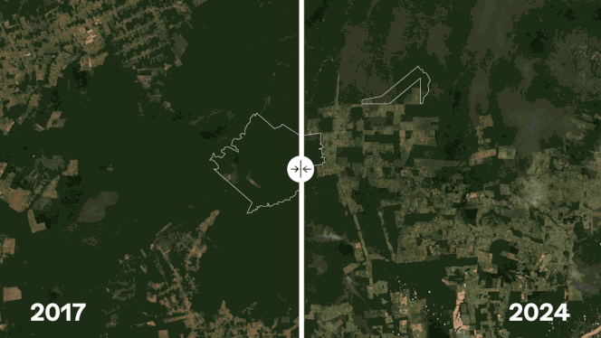
How to find it
* All content is copyrighted by Industry Intelligence, or the original respective author or source. You may not recirculate, redistrubte or publish the analysis and presentation included in the service without Industry Intelligence's prior written consent. Please review our terms of use.


