OTTAWA
,
September 13, 2023
(press release)
–
Agroecosystems are mosaics of different land covers and uses, including annual and perennial croplands and pastures and semi-natural habitat. These managed ecosystems deliver essential ecosystem services, contributing towards the provision of food for humans and livestock while also providing habitat for various species, climate regulation services, space for recreation and support for cultural heritage. Statistics Canada is releasing an accounting framework for measuring agroecosystem extent, condition and ecosystem services. The accounts and selected data released today are part of Statistics Canada's Census of Environment program, which will eventually report on all ecosystems in Canada. In 2021, agroecosystems covered nearly 57 million hectares of land in Canada. Overall, just under 58% of Canada's agroecosystems were annual croplands, 42% were sown and semi-natural pastures and forage areas, and less than 1% were perennial croplands. Ecoprovinces in the Prairies had the highest share of their total area classed as agroecosystems, with this share ranging from 67% to 86%. Total agroecosystem area in Canada decreased by approximately 3.9 million hectares from 1986 to 2021. Annual cropland areas decreased by 3.3 million hectares and semi-natural pasture areas decreased by almost 1.9 million hectares. On the other hand, sown pastures and forage areas increased by 1.2 million hectares and perennial croplands increased by over 54 000 hectares. The Parkland Prairies ecoprovince lost the most agroecosystem area (-486 000 hectares) overall, largely because of reductions in annual croplands and semi-natural pastures. Agroecosystem extent declined by over 358 000 hectares in the Great Lakes–St. Lawrence Lowlands ecoprovince, largely because of reductions in pasture and forage areas. The condition of agroecosystems can be measured with a range of variables. Soils are a vital component of agroecosystems but are vulnerable to erosion if not properly managed. From 1986 to 2021, soil erosion risk decreased in 86% of ecoprovinces. In 2021, the Huron–Erie Plains ecoprovince in southern Ontario had the highest erosion rate, with an estimated 17 tonnes of soil eroded per hectare per year. Pesticides are often used to control organisms that hinder crop growth. Pesticides can also affect non-target organisms and can have negative impacts on the surrounding environment. From 1986 to 2021, the use of herbicides, which target weeds, increased by 28%, from 22.9 million hectares to 29.3 million hectares. Notable increases have been in the Central Grassland and Central Boreal Plains ecoprovinces, where the combined herbicide application area increased by over 4.5 million hectares. Agroecosystems provide the food people rely on every day. In 2021, agroecosystems produced approximately 109 million tonnes of crops used for food, animal feed and industrial use, as well as 11 million tonnes of forage for grazing livestock. In addition, agroecosystems provide other valuable services, including climate regulation, water flow regulation and soil retention. Statistics Canada's new Census of Environment program reports on ecosystems in Canada, providing information to help Canadians make evidence-based decisions to protect, rehabilitate, enhance and sustain our environment. It follows the internationally accepted environmental–economic standard for producing information on ecosystems' extent, their condition and the services they provide. This release provides a framework for the development of agroecosystem accounts and includes estimates of agroecosystem extent and condition. Moving forward, the Census of Environment program aims to improve and expand on these estimates and begin quantifying the ecosystem services provided by agroecosystems. Data on agroecosystem extent and condition are now available for the years 1986 to 2021 in tables 38-10-0164-01 and 38-10-0165-01. These data allow Canadians to analyze historical long-term patterns in agroecosystem area and condition from 1986 to 2021, by ecodistrict, ecoregion and ecoprovince. For more information, see Canadian System of Environmental-Economic Accounting – Ecosystem Accounts (5331).Agroecosystem extent decreased since 1986
Map 1

Canadian agroecosystem extent, by agroecosystem type, 2021, based on Earth observation data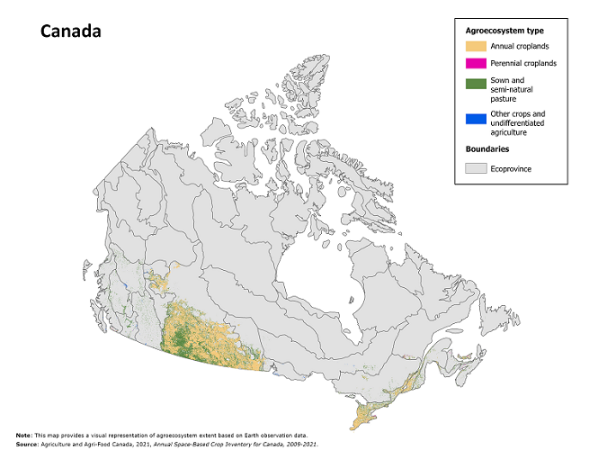
Risk of soil erosion decreased in most agroecosystems
Agroecosystems provide a variety of essential ecosystem services
Chart 1
Share of agroecosystem area, by type, 2021
Chart 2
Top ten ecoprovinces with largest increase in herbicide application area, 1986 to 2021
Note to readers
* All content is copyrighted by Industry Intelligence, or the original respective author or source. You may not recirculate, redistrubte or publish the analysis and presentation included in the service without Industry Intelligence's prior written consent. Please review our terms of use.


